The 6th Street Viaduct (designated as City of Los Angeles [City] Bridge No. 53C-1880 and California Department of Transportation [Caltrans] Bridge No. 53-0595 [portion of viaduct over Hollywood Freeway or US 101]) is located in a highly urbanized area just east of downtown Los Angeles. The viaduct connects the downtown portion of the North Central Community Planning Area with the Boyle Heights Community Planning Area in the City and County of Los Angeles. The viaduct extends east-west across the Los Angeles River, Union Pacific Railroad (UPRR) and Metrolink tracks, US 101, and several local streets.
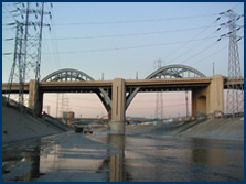
The 1986 Caltrans' bridge survey found the 6th Street Viaduct to be eligible for inclusion in the National Register of Historic Places (NRHP). The viaduct is 3,500 feet long. It has a 46 foot wide, four-lane roadway with 11-foot eastbound and westbound inside traffic lanes and 12-foot outside lanes with no shoulders. There are sidewalks of varying widths on both sides.
In June 2004, the City completed a Seismic Retrofit Strategy Report. The report studied options for either seismically retrofitting the existing viaduct or demolition and construction of a replacement viaduct. The study evaluated the structural efficiency of retrofitting, seismic vulnerabilities, and capital and life cycle costs of various strategies. The proposed project will provide seismic safety for this critical Los Angeles River crossing by either retrofitting or replacing the 6th Street Viaduct.
|